


How to Build a Citizen Reporting App for Municipal Services
Modern cities need efficient ways to identify, prioritize, and resolve everyday problems reported by residents. Broken streetlights, potholes, overflowing waste bins, damaged sidewalks, illegal dumping, and other public infrastructure issues can affect safety and quality of life. However, traditional reporting methods such as phone calls, emails, or in-person visits often create delays and make it difficult for citizens to track what happens after a complaint is submitted.
A citizen reporting app can help municipalities create a more transparent and efficient communication channel between residents and local authorities. By combining mobile technologies, geolocation, workflow automation, and data analytics, municipalities can receive better information and respond to issues more effectively.
This article explains how to build a citizen reporting app for municipal services, including the essential features, architecture, development process, and key challenges.
Understanding the Purpose of a Citizen Reporting App
The main goal of a citizen reporting application is to simplify the process of reporting public issues. Instead of searching for the correct municipal department or describing a location manually, residents can use their smartphones to submit a report within minutes.
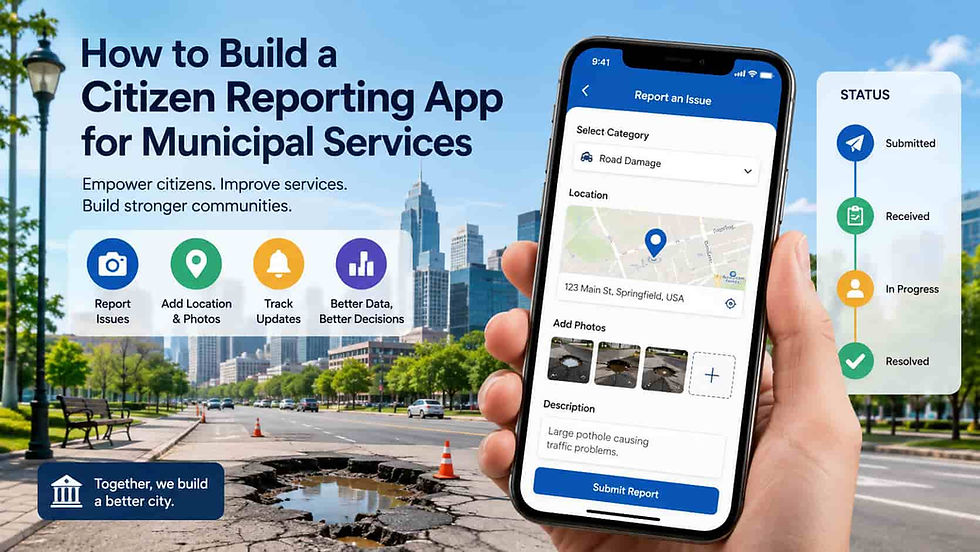
A typical reporting process may look like this:
A citizen identifies an issue, such as a damaged road.
The user opens the application and selects the appropriate issue category.
They add a photo and optional description.
The app automatically captures the location through GPS.
The report is submitted to the municipal platform.
The responsible department receives and processes the request.
The citizen can track updates until the issue is resolved.
This approach creates a structured flow of information and reduces the administrative effort required to process incoming complaints.
Define the Core Features
The first step in building the application is identifying the features required by citizens and municipal employees. A minimum viable product should focus on making reporting fast and convenient.
Issue Reporting
Users should be able to select an issue category, add a description, upload photos, and submit the report. Categories may include roads, public transportation, waste management, parks, lighting, water infrastructure, and public safety.
The application should also allow administrators to modify categories without requiring a new version of the mobile app.
GPS Location and Interactive Maps
Location information is essential for municipal services. The application can automatically detect the user's position or allow them to place a marker manually on an interactive map.
Accurate location data helps service teams identify the exact problem area and plan maintenance activities more efficiently.
Photo and Video Attachments
Visual evidence can significantly improve the quality of a report. A photo of a pothole or damaged streetlight provides municipal employees with more information than a text description alone.
The system should compress and optimize uploaded files while preserving enough quality for municipal teams to evaluate the issue.
Status Tracking
Citizens should be able to see what happens after submitting a request. Typical statuses may include:
Submitted
Received
Under review
Assigned
In progress
Resolved
Closed
Status notifications improve transparency and can reduce the number of follow-up calls to municipal offices.
Notifications
Push notifications, emails, or SMS messages can inform citizens when the status of their report changes. Notifications may also encourage users to provide additional information when a report is incomplete.
Design the Municipal Workflow
A mobile application alone is not enough. Municipal employees need an administrative platform where they can review, prioritize, assign, and manage incoming reports.
When a new issue is submitted, the system can automatically determine which department should receive it. For example, reports related to waste collection can be routed to sanitation services, while road damage can be assigned to transportation or infrastructure departments.
Workflow automation can also consider factors such as location, issue category, severity, and existing service zones.
An effective administrative dashboard should provide:
A map of reported issues
Filtering and search capabilities
Assignment tools
Priority management
Service-level deadlines
Communication with citizens
Reporting and analytics
These capabilities allow municipalities to transform individual reports into organized operational tasks.
Choose the Right Technical Architecture
The architecture should support mobile applications, administrative users, integrations, and potentially thousands of reports.
A common solution includes several components:
Mobile application. Native Android and iOS applications can provide the best integration with device features such as cameras, GPS, and notifications. Cross-platform frameworks may reduce development time when municipalities need to support multiple operating systems.
Backend platform. The backend manages authentication, report processing, workflows, notifications, and integrations with municipal systems.
Database. A relational database can store users, reports, departments, and workflow information. Geospatial capabilities are particularly useful for searching and analyzing reports by location.
Cloud infrastructure. Cloud services can provide scalable storage, computing resources, backup capabilities, and high availability.
Administrative portal. Municipal employees typically require a browser-based platform for managing reports and monitoring operational performance.
As part of smart city software development, the platform can also be designed to exchange information with other digital city systems, such as traffic management platforms, IoT sensors, public asset management systems, and open data portals.
Integrate GIS and Mapping Technologies
Geographic information systems play an important role in citizen reporting applications. Reports become more valuable when they can be analyzed spatially.
For example, a municipality may discover that numerous pothole reports are concentrated in a specific district. Instead of responding to every complaint individually, authorities can schedule a broader maintenance project.
GIS integration can support:
Location-based report assignment
Identification of problem clusters
Service area management
Infrastructure asset mapping
Historical analysis
Heat maps of recurring problems
Combining citizen reports with municipal geographic data can help decision-makers identify infrastructure issues before they become larger and more expensive.
Build for Scalability and High Usage
Municipal applications may experience sudden increases in activity during severe weather, infrastructure failures, or public emergencies. The technical infrastructure should therefore be capable of handling traffic spikes.
A scalable architecture may include load balancing, cloud-based storage, database optimization, caching, and asynchronous processing.
For example, uploaded images can be processed in the background rather than delaying the report submission process. Notification delivery and integration tasks can also be handled asynchronously.
Development teams should test the application under realistic conditions, including a large number of simultaneous users and reports.
Focus on Security and Privacy
A citizen reporting application may collect personal information, location data, photographs, and communication history. Security and privacy should therefore be considered from the beginning of the development process.
Important security measures include:
Secure authentication
Role-based access control
Encryption of sensitive data
Secure API communication
Data retention policies
Regular security testing
Logging and monitoring
Protection against unauthorized access
Municipalities should also clearly explain what information is collected and how it will be used. In some cases, citizens may need the option to submit reports without publicly displaying their identity.
Improve Citizen Engagement
The success of the application depends on whether residents find it easy and useful to use. A complicated reporting process can discourage adoption.
The user interface should therefore be simple and focused. Citizens should be able to submit a basic report in only a few steps.
Additional engagement features may include the ability to support existing reports instead of creating duplicates, comment on public issues, receive local service updates, or view reports on a city map.
However, municipalities should carefully moderate public content and establish rules for comments and uploaded materials.
Use Data Analytics to Improve Municipal Services
Over time, the application will generate valuable operational data. Municipalities can analyze which problems occur most frequently, where they are located, and how long they take to resolve.
Useful performance indicators may include:
Number of reports by category
Average response time
Average resolution time
Number of unresolved issues
Geographic distribution of reports
Recurring problem locations
Department workload
Predictive analytics may eventually help authorities anticipate infrastructure problems and allocate maintenance resources more efficiently.
This turns citizen reporting app development into more than a communication project. When combined with analytics and operational systems, it can become a valuable source of information for long-term urban planning and service improvement.
Plan the Development Process
A structured development process reduces risks and helps municipalities launch a useful product faster.
The process may begin with stakeholder interviews involving citizens, municipal employees, service providers, and IT departments. These discussions can identify the most important reporting categories and existing operational challenges.
The next step is creating user journeys, wireframes, and technical requirements. A prototype can then be tested with a small group of users before full-scale development begins.
An MVP should focus on the essential capabilities: user access, issue reporting, location detection, media uploads, workflow management, and status tracking.
After launch, the municipality can collect feedback and introduce additional functionality based on actual user behavior.
Conclusion
A citizen reporting app can make municipal services more accessible, transparent, and efficient. By allowing residents to report problems using photos, descriptions, and location data, municipalities can receive structured information and route requests to the appropriate departments.
The most successful solutions combine an intuitive mobile experience with a powerful administrative platform, automated workflows, GIS integration, security, and data analytics. Starting with a focused MVP and expanding the platform based on real-world feedback can reduce implementation risks and improve adoption.
Ultimately, a well-designed citizen reporting platform does more than collect complaints. It creates a direct digital connection between residents and municipal services, helping cities respond faster, understand recurring problems, and make better decisions about infrastructure and public resources.
Comments